
The Grand Plan

“Throw everything out the window because what you expect is not going to happen.” -Brian Donnelly, Oregon PCT Record 2013
I include this quote at the header of pretty much every FKT plan I’ve ever made. The itinerary I drafted up for Kungsleden is my ideal, best case scenario, everything-going-right plan.
I would normally be a bit hesitant to share such details about my goals. If I fall off of the plan, I don’t want anyone that’s following along to feel disappointed that I’m not reaching or exceeding expectations.
However, there’s something to be said about making your intentions known. I believe I can carry out this plan I made for myself. I also believe that I will make the best decisions out there in the moment, and roll with the punches and adapt as necessary.
While the most popular direction to hike Kungsleden is north to south for thru-hikers and FKTers alike, I am choosing to hike northbound from Hemavan in the south, to Abisko in the north. This way, I’m getting some of the boggier, more forested, and more remote sections out of the way early in the journey, and I’m saving some of the most brilliant scenery and landscapes up north for the end; plus I’ll be going the opposite direction of most hikers in the busier sections of the trail.
One of the bigger logistical challenges is the seven water crossings that are necessary to cross by boat. Most are motorized and adhere to certain timetables, crossing only twice per day in most cases. For at least one water crossing, I will have to row myself! This will add to the adventure, for sure.
There is currently no women’s self-supported record for Kungsleden. (Emelie Forsberg holds the women’s supported record - watch her amazing video!). In that sense, it takes some of the pressure off. This is my journey; I’m not trying to replicate anyone else’s hike. However, I do care very much about doing my best and seeing if I can actually pull off this wild plan in some form.
Without further adieu, here is my grand plan! You can follow along by subscribing to these updates below if you’re not already, and checking out my tracker on my Kungsleden page.
DAY 1 HEMAVAN TO AMMARNÄS 49.3 miles, 8858 ft gain (map)
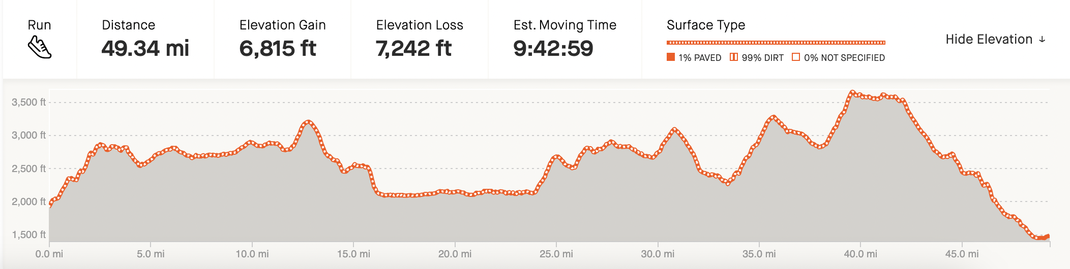

Photo: Reboot Life
The southern end of Kungsleden is Hemavan. A hike from here and north through the Vindelfjällen nature reserve to Ammarnäs is like hiking in miniature Lapland. Impressive massifs of high rugged mountains and deep green valleys are interspersed with wetlands rich in birds, mountain birch forests and lakes rich in fish.
There are five STF mountain cabins along the route, most of which have small shops with provisions. The trail starts uphill to Viterskalet. It continues through the Syterskalet valley, where the contrast between the valley's verdant bottom and its steep, mighty mountain sides can be experienced. The penultimate section is the longest, then the second highest point of the Kungsleden is passed. The end to Ammarnäs slopes comfortably downhill. (source)
Most hikers break up this section into six days. I’m attempting to hike it in 12-14 hours!
Lodging: I’ll stay at STF Ammarnäs Wärdshus, a homey lodge located in the small village of Ammarnäs. Ammarnäs is a genuine mountain village situated in the middle of the Vindelfjällen nature reserve, one of the largest protected areas in Europe. It is also a traditional area for the Sami people. There are three Sami villages, Gran, Ran and Ubmeje, nearby as well as several remains of old Sami settlements. The hostel is in the centre of all this, and was used as a home for elderly Sami until 1968.
Resupply: In Ammarnäs, there is a grocery store open until 6pm, and a restaurant open until 8pm. There are also three STF mountain cabins with provisions along the way.
DAY 2 AMMARNÄS TO JÄKKVIK 57.2 miles, 7,406ft gain (map)


Route description and photo from Reboot Life:
“This section is one of the least popular on Kungsleden. Perhaps this is due to the lack of infrastructure like huts. On the contrary, it was really nice to have the trail to ourselves. On most days we did not meet more than one or two hikers. Still, I can see why this is less popular to hike. While the views along the route are intermittently impressive, the section consists more of wild forests than majestic mountainous fell. It is also a pretty demanding stretch due to the hilly nature, the trail constantly moving up and down between river valleys and and the highland plateaus in between. Looking back this was my least favorite part of Kungsleden over all. We did have pretty bad weather on this stage though, lots of rain and cold temperatures, which might have influenced my overall impression. Still, this is a thru-hike after all so you have to take the good and the bad. But I am happy we are walking nobo, because then we will do this (and the next) section early, saving the best for last.”
I wrote a note to myself for this day: “You did this in Colorado with 2,800ft MORE gain. You can do this!!” Although I failed in my Colorado Trail FKT attempt last summer, I covered two 60 mile days in a row with a full pack and at high altitude, and felt good doing so (at least in the moment), which gives me confidence for this Day 2 plan.
Unlike Colorado, in Sweden I will be traveling lighter as I don’t need to carry as much equipment or food, and by comparison I’m starting with “only” 106.5 miles over two days, at lower altitude with fewer elevation changes. However, I don’t want to underestimate the difficulty of these two days. Looking at the weather forecast, it will likely be cold, rainy, and muddy. I am planning to get an early start on this second day to be on the safe side.
Lodging: I reserved a cabin in Jäkkvik located right across the street from ICA.
Resupply: ICA grocery store in Jäkkvik, open until 8pm; there is also a restaurant open 12-6pm at Bäverholms Wärdshus 17 trail miles south of Jäkkvik, and a grocery store in Adolfsström, 13 trail miles south of Jäkkvik (no hours listed).
DAY 3 JÄKKVIK TO KVIKKJOKK 55.8 miles with three water crossings - Kapellströms (300m rowing), Riebnes (3.3 miles by motorboat), Sakkat (2 miles by motorboat) // ~50.4 miles; 8,233 ft gain (map)

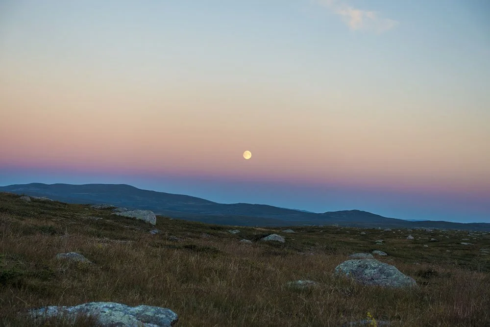
Photo: Reboot Life
Jäkkvik-Kvikkjokk, 80 km, is one of the most varied stretches of the Kungsleden. The path, unlike the stretch north of Kvikkjokk, is not used often. The mountains consist of foothills and the view from them extends many kilometres. Between areas on the barren mountain top, the hiker goes through lush birch forests and old forest areas near the mountains with an occasional large pine tree. A bit up from Lake Sakkat, the Kungsleden goes through sparse birch forests and meadows, a landscape likening that of a park, made totally by nature. The Arctic Circle is 19 trail miles north of Jäkkvik (source).
This will likely be a challenging day due to the timing of the Riebnes lake crossing.
3.5 trail miles north of Jäkkvik, I will row 300m across Kapellströms. There are several boats available for hikers to use. If there is more than one boat on my side of the lake, perfect–all I have to do is row across. If there is only one boat remaining on my side, I will have to row across, then tow another boat back across to where I started, then row to the other side one final time. That way, no hiker is left without a way to get across. Hopefully I will only have to make one trip!
Seven miles after crossing Kapellströms, I’ll need to catch the 9am boat across Riebnes lake. The only other daily crossing is at 4pm–so I must catch this boat! I confirmed my reservation with the boatmaster Eva ahead of time by email.
Once I land on the north side of Riebnes, it’s GO TIME! There are 39 miles between there and the next boat crossing at my end destination for the day, Lake Sakkat, on which the north side lies the town of Kvikkjokk. Kvikkjokk is one of the oldest settlements in Swedish Lapland and is surrounded by a rich fauna, Sámi culture and ancient remains of the Vikings.

The church in Kvikkjokk, which I’ll see on the way to my cabin. Hopefully it will still be light out! Source: Wiki
The boatmasters Helena and Björn said I could message them just before starting my hike downhill toward the lake, where they have a sign that reads 6,5km to the dock. They asked for me not to arrive later than 10pm if possible.
If I’m not able to make it to the lake by 10pm, I’d have to wait until the next morning, which will make logistics for Day 4 more difficult than they already are. So, it is in my best interest to RUN as much as possible for those 39 miles and make excellent time.
Lodging: I booked a cabin in Kvikkjokk with self check-in, since I read the STF Mountain Station will give away your bed if you don’t arrive by 6pm, which I certainly won’t!
Resupply: I read that there are meager food resupply options at the Kvikkjokk Mountain Station, and I might not even get there while the shop is open. So, it will be best if I purchase enough food in Jäkkvik (Day 2) to last until I reach Aktse (morning of Day 4, if all goes to plan).
DAY 4 KVIKKJOKK TO SALTOLUOKTA 44.8 miles with two water crossings - Laitaure lake by Aktse (1.7 miles rowing OR by motorboat and Sitojaure (2.5 miles by motorboat) // 40.6 miles hiking, 5,648ft gain (map)


Photo: Reboot Life
The Kungsleden walking trail between STF’s mountain stations at Kvikkjokk and Saltoluokta is about 70 km long. The trail takes you through countryside straddled between Sareks high mountains and the forest landscape to the east. You cross open moors, descend through sparse mountain forests, and take boats over large lakes. From Kvikkjokk, there are plenty of lakes, barren mountain landscapes and old coniferous forests. Toward Saltoluokta, you go through a beautiful plain landscape with alpine bearberries, willows and the occasional mountain birch (source).
This is where things could get hairy, if they’re not already hairy. I need to run/hike 22.4 miles from Kvikkjokk to Laitaure by 8:30am, or 9am at the latest to catch the only morning motorboat crossing of Laitaure. In the case that I miss the boat, I have the option of rowing myself across, which according to Anna, the boatmaster at Sitojaure, takes 30-45 minutes. So, it’s not the end of the world if I have to row myself, but I’m not the most experienced rower and 1.7 miles is a whole lot of open water to cover.
Then from Aktse, which lies on the north shore of Laitaure lake, it is 8.4 km / 5.2 miles to the next lake crossing of Sitojaure, which has one afternoon crossing at 2:30pm. I certainly don’t need 5 hours to hike 5.2 miles, so I will plan to stop for a slightly extended break at STF Aktse Mountain Cabin to eat, take care of my feet, and whatever else I need to do before hiking on.
After crossing Sitojaure lake at 2:30-3pm, it is another 12.2 miles to reach the promised land, STF Saltoluokta Mountain Station. They offer dinner at 7:45pm, so my goal is to make it there before 7:45pm.
Lodging: STF Saltoluokta Mountain Station
Resupply: STF Aktse Mountain Cabin
DAY 5+ SALTOLUOKTA TO ABISKO 85.7 miles with two water crossings - Lake Langas (1.2 miles by motorboat) and Teusajaure (0.5 miles by motorboat or rowing) - and 18.3 mile bus ride // 65.7 miles of hiking (map)


Photo: Reboot Life
“This last stage is the most popular section of Kungsleden and it is easy to see why. The trail passes trough some really stunning scenery… the majestic Tjäktjavagge vally, the impressive Kebenekaise mountain range and a climb up to the highest point of the entire trail, Tjäktjapasset.” (Reboot Life)
This day will have an interesting start. The Saltoluokta Mountain Station is located on the southern side of Lake Langas. The first ferry crossing of the day is not until 10:20am (the last crossing the day prior is at 4:10pm, and I don’t trust that I could make it in time because of the 2:30-3pm Sitojaure crossing, which is over 12 miles from Saltoluokta).
On the one hand, this is a bit of a bummer. If I stay on track with my schedule above, and if I were able to get an early start on this final stage, I would have a chance to break Emelie Forsberg’s supported record of 4 days, 21 hours, 45 minutes.
On the other hand, this is my own journey, and I’m doing it my way: south to north, self-supported. While the late start isn’t ideal, it’s out of my control, and I can use the extra time to my advantage. It means I will be able to get extra sleep, extra food, time to reorganize my things, let my likely blistered feet breathe a little, and be “fresh” (ish) and ready to roll for the final push to Abisko.
If I’m very late arriving to Saltoluokta the night before, the 10:20am lake crossing will also give me a little breathing room. There’s even an extra ferry at 11:30am due to the popular hiking season, which I could end up needing if I get delayed and can’t cross Sitojaure in the south until the morning crossing at 8:15am (which would still only give me 3 hrs 15 minutes to hike the 12+ miles between - eek).
After the 10:20am lake crossing, I’ll take the 10:40am bus to where the trail connects 18.2 miles down the road at Vakkotavare. “A bus??”, you say? Yes, this connector bus (or alternative vehicle transportation) is commonly taken by hikers, including those that have set Fastest Known Times.
From Vakkotavare, where the bus will drop me off at noon, the hike starts with a steep uphill and ends with a steep downhill through Stora Sjöfallet national park. After 15 kilometers / 9.3 miles I’ll arrive at Teusajaure, the final lake crossing of my journey. I’ll have the option of rowing across (~1 kilometer), or I can catch the 5:15pm motorboat crossing. I am hoping for good weather and calm water to give me confidence to row across on my own!
From the north side of Teusajaure lake, it is 56.8 miles to the northern terminus in Abisko. I can hike through the night and finish as close to 5 days as possible (which will be exactly 5 days from whatever I time I start in the morning from the southern terminus on August 14th- easy math). There are also many huts along the way (every 10-20 kilometers), as it is the most well-traveled stage of Kungsleden. From what I understand, even when huts are full, you can pay a small fee to pitch your tent outside and use their facilities. So, if I run into trouble with weather or need a place to rest, I will never be terribly far from a mountain hut (since this stage goes through a national park and protected areas, there are limitations on where you can camp).
So there you have it! Can I pull it off? We shall see. Will it be a grand adventure? Most definitely!
You can follow along my journey by visiting my Kungsleden Info + Tracking page and signing up for my Kungsleden Trail Dispatches mailing list below if you haven’t already done so.
💫